Saturday 3 March
Distance: 8.5 miles (2700’ of ascent)
Weather: Sunshine and showers, probably more dry than wet
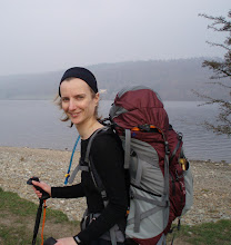
A large school group was standing around in the rain as we sat in the comfort of Colin on Saturday morning trying to decide what to do with our day. We kept looking out to see what they were doing, and for over half an hour they just stood there. I think I’d have been pretty grumpy to have started my day by standing in the pouring rain for that long wearing a big backpack!
Half an hour after they set out, we followed in their footsteps, heading towards Caiston Beck. Having ruled out the hills that I want to do in good weather, we’d settled on High Pike and Low Pike as our objectives for the day. Brothers Water isn’t the most obvious start point to do those two hills, but with the last forecast we’d seen having suggested low cloud, many hours of rain and some strong winds, two hills of 656m and 508m looked like a sensible choice (and we’ll gloss over the fact that we climbed up to over 750m before descending to High Pike…).
Someone must have slipped some bricks into our bags and lead into our shoes, as by the time we were on the final approaches to Dove Crag (which wasn’t on our agenda; having been up there a couple of months ago we turned off just before the summit) we were both flagging. Finally dragging our weary legs over to the ridge wall, down we plonked ourselves for an early lunch in the hope that it would perk us up.
“Looks like the sun’s about to come out” said one of the chaps who had stopped a few feet away for a butty-break of their own.
“I’d just been saying that myself” I responded, as we all looked doubtfully at the thick cloud that had been enveloping us since early in our outing.
Not five minutes later, without prior warning, a hole appeared in the cloud and out came the sun! There was more rain, a few hail showers and the wind did continue, but for a chunk of the early afternoon the sky was a gorgeous blue. In fact, contrary to the forecast I would say that the day was as dry as it was wet.

High Pike on the left, Scandale Pass on the right – and finally the cloud is lifting so that we can see them
What of the ‘Gradual Gradients Are For Girls’ though? If you look at the map of our route, you’ll see that our ascent route was nice and gentle. For today we had saved the ridiculous gradient for our descent. Standing atop Low Pike we shunned the sensible (but longer) route, and instead looked down at the slightly-craggy slope below and decided that it looked doable. I’m sure that anyone watching us (and there was no short supply of people around) would have classed us as either clueless or stupid, but we’ve certainly made more severe descents and not only did we make our way successfully through the crags to our earmarked hole in the wall, but we also got across the beck dry-shod (something that hadn’t looked a certainty from up high).
As I mentioned, Brothers Water isn’t the obvious starting point for these two hills (Ambleside would probably the popular choice), so our descent from Low Pike didn’t end our day as we still had to get back over into the Patterdale valley. The Scandale Pass served our purpose to get us there and the woefully unwilling legs that carried me up there were nicely counter-balanced by the sheer joy of the turn in the weather.

Heading up to Scandale Pass – what a contrast to an hour or so earlier!
It wasn’t encouraging, being so weary after such a modest outing, and without a big pack, but otherwise it had been a good and enjoyable day.


What a beautiful blue sky!
ReplyDeleteBy the way, is it Anquet that you use to create those annotated OS maps? I'd love to get started with putting something like that on my blog.
Point of order: I felt fine all the way through the walk - leaping up the hills like a gazelle. I was merely pretending to be tired when Gayle was watching me, just to make her feel better. Honest!
ReplyDeleteHi Karen!
ReplyDeleteThe maps on this set of posts are from Memory Map, but only because the Garmin Gadget won't download a route properly to Anquet. I do usually use Anquet though. Whichever I use, I just do a screen dump into Paint, crop it and then copy it into the blog post.
For what it's worth, I'm not a fan of Memory Map. It has a couple of features that I like, but on the whole I do prefer Anquet (which is how I came to fork out on new Anquet maps within two weeks of having switched to Memory Map!).
Not that I've got more mapping software than is reasonable, but I've also got Quo, and when I want 1:25k map sections I subscribe to Grough Route for a month...