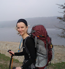
Having snuck a day off work, last Thursday morning saw us throw a few things into the back of Colin and set of up to Robin Hood’s Bay, where we arrived early in the afternoon. Pausing only for lunch, a cup of tea and cake, we headed off down towards the Bay (we were staying just above it) to take a short circular stroll in the direction of Ravenscar.

Navigationally, things did not go well! Could we find where the Cleveland Way path left Robin Hood’s Bay to the south? Nope. Down to the beach we went…


…without having seen any sign of an acorn waymark or a path since before we dropped down through the village. I looked at the map and realised that was because the path was back up there, right by the telephone box. So, back up we went (if you haven’t been to Robin Hood’s Bay then you’ll not know quite how steep that road is!), but despite significant poking around, we just could not find any trace of the path.
Not to be defeated we modified our plan. It was a circular walk, and we would walk it in the opposite direction thus flushing out the location of the missing path on our return. Out along the Cinder Track (disused railway track) we went until the hour of day suggested that we should head back, whereupon we took the opportunity to turn towards the coast at the next road junction.
That happened to lead us to Boggle Hole, where finally the grey sky decided that it could hold its water no more. That didn’t put off the hoards of children who were on the beach just below the Boggle Hole Youth Hostel (no doubt on a school trip which had booked the place out).

Mick suggested that we should walk back along the beach, but that would have left the location of the Cleveland Way a mystery, so up from the bottom of Boggle Hole we huffed and puffed before heading along the cliff top back to our start point.
 It turned out that there is a clear acorn and ‘Cleveland Way’ sign, which we had missed, down one of the little side streets just before the beach in Robin Hood’s Bay (which isn’t where the 1:50k map made it look like the path lay – but that’s always the problem trying to navigate in a place where there are lots of buildings shown – they drown out the pink dashed line). At least now, if we come to walk the Cleveland Way heading south along this section, we won’t go awry!
It was a pleasant afternoon’s stroll, of 6 miles in length. Pity about the greyness; it seems to be our theme this year.

*If* I'm going to get lost, it'll be in amongst buildings. Every time.
ReplyDelete