Mochrum Fell (NX723750; 317m)
The first and least adventurous walk of the day was a 4.3-mile out-and-back up Mochrum Fell.

I was equally tempted to try the track on the way back, but with yesterday fresh in my mind, I went for the 'better the devil you know' option and retraced my steps.
The kettle was on when I got back, which was handy as it was feeling very much like second breakfast time.
Cairnsmore (Black Craig of Dee) (NX583758; 493m)
Next came the biggest adventure of the day. Up there with yesterday's second hill, it was.
I had two options noted for this hill. Most people seem to walk in from the mast-maintenance track to the west. At best this route is described as 'rough' and one person noted that it was the worst tussocks they'd ever come across - and this was their 600th Marilyn. This option would have been 2.8 miles each way.
My second option, and the one I went for, was to attack the hill up its steepest side, having first made my way, tracklessly, through a forest plantation. That option was 1.1 miles each way, and the only description I found of the going was a single word: 'sporting'!

note the tight packed contour lines towards the top
Hampered from the outset by failing to find the break in the trees that I was looking for (actually, I found on my return that I had started off following it, but had missed its continuation when it veered right), a bash through the forest ensued. How many times have I sworn I'll never bash through a commercial plantation again?!
Making it out of the trees would have been cause for celebration if I wasn't now faced with a ridiculously steep ascent through some obscenely rough terrain. I gave more serious contemplation to turning back than I have ever done before, but two things stopped me: 1) I didn't want to have to negotiate the forest again; and 2) the other approach would be longer and probably just as rough, even if not as steep.
I did make it to the top and, as I had ascertained that, from above, the break through the trees, which had been so elusive from below, was perfectly obvious, I discounted the option of asking Mick to drive around to the west side.

A slightly different line was taken down, and it was every bit as hard and slow as the upwards haul had been. With boulders, tussocks and big holes completely masked by hip high grass, not to mention the ridiculous steepness, I really had to take my time and be sure of each step.
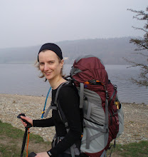
Arriving back at Colin ("You've got blue lips!" said Mick; "So many ripe bilberries!" I replied and as I was moving so slowly it was easy to keep grabbing the odd handful) I had walked 2.2 miles, with 1000' ascent at an average speed of 1.1mph, making this my slowest hill to date. It was still quicker than the longer route in would have been, though.
Fell of Fleet (NX566707; 470m)
I'd been undecided whether to go for this one today, due to the length of the walk in (many people drive the forest track, but I discounted that option on Colin’s behalf), but after a very long lunchbreak I resolved to go for it, hoping that it would be somewhat easier than Cairnsmore had been.
The walk in was, of course, straightforward, as was the section after leaving the forest track and taking to an old trackway. The route description I'd noted from hill-bagging.co.uk told me that the trackway would end amongst young conifers and that a path would then take me to within 0.5km of the top.
Reaching a junction on the old trackway, I was a bit flummoxed. No-one had mentioned a junction! Which way to go? I plumped for continuing on the line shown on the 1.25k map (this track doesn't appear on the 1:50k). That may have been a mistake, as I certainly didn't find any sort of a path when I struck off up the hill.
There then ensued a kilometre of hard yomping, during which I concluded that this is not a good time of year to be doing these hills, with all of the long grass hiding the tussocks and holes that lie beneath.
It was a nice summit, but I could see that the weather was closing in on me, so I didn't spend too long admiring the views before I chose a downwards line (which proved significantly wetter underfoot than my outwards one had been).
The drizzle started as I reached the forest track, whereupon my speed increased to 'as fast as my little legs can carry me without running'. Ten minutes before I got back to Colin the drizzle turned to rain. It was a soggy Gayle who pitched up on his doorstep.
The outing had come in at 8.2 miles with 1200' of ascent at an average speed of 3mph. Given how slow the yomp to the summit had been, I deduce that I really had been going some along the forest track!

You are now a truly hardened Marilyn bagger; there is no doubt.
ReplyDeleteAnd thus, by definition, also a little bit mad.
DeleteYou look super-cool in your shades!
ReplyDeleteMaybe I am just super-cool! ROFL.
Delete