Beinn Ghlas (NN131182; 550m)

The track that leaves the A819 and leads up to Accurach Farm has been extended since my map was published, such that it now meets up with the track to the SE. That was handy for us, although we did notice that it merrily attacked every wiggle in the contours that lay in its way.
Just as it met the old track, we left it and yomped upwards, attacking more wiggles in the contour lines as we went, until there before us was a cairn on an outcrop. That wasn't quite the top, but after visiting it we made our way the final 50m to the rocky outcrop that is the summit. Then, for completeness, we visited the trig point.
Impressively, I thought, considering the lumpy bumpy landscape, we hit the track on our return at the exact same place as we had left it on our way up, from where it was just a 2.5 mile walk back the way we had come.
(7.2 miles with, I suspect, more than the expected 450m of ascent (I'm almost certain that when I came up with that figure I hadn't taken into account the ascent on the return leg.)
Meall an Fhithich (NN059267; 294m)

I'd read on hill-bagging.co.uk of a car park provided for walkers at the start of this walk, so when we found a large, flat gravelled area a couple of hundred metres down the estate track, immediately before the big iron estate gates, we assumed that to be it and Bertie was neatly abandoned.
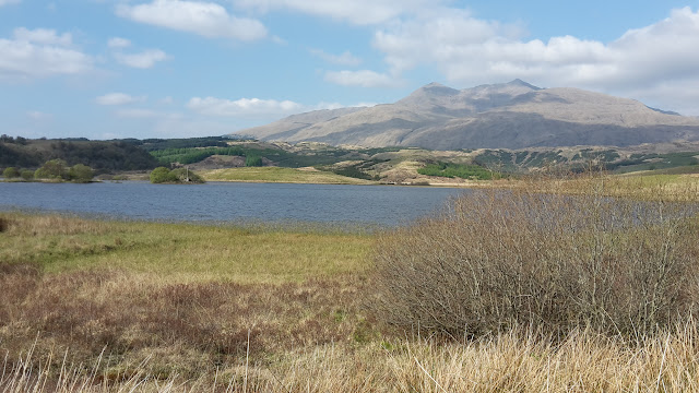
Another undulating track, with good views of Ben Cruachan...
...took us towards our objective until we came to a sign of whose meaning I still can't quite understand in its entirety...
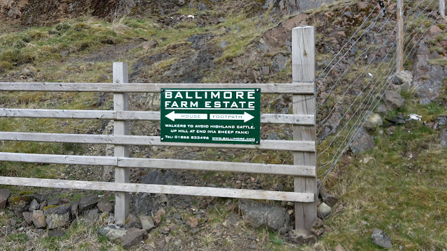
what are they trying to say about the cattle and how is it relevant to the path?
...but they clearly didn't want us to walk past the buildings, so we obliged by taking the unmapped track, which was slightly further, but no trouble.
Then all we had to do was attack the hill head-on, pushing our way through a blanket of dead bracken, between young trees, before reaching the top of the steep bit, whereupon just half a dozen pimples lay between us and the top. The deep dead grass and tussocks up there would have been only mildly remarkable, if the estate hadn't dug holes at random intervals all over the place, making it feel a bit like an obstacle course.
We chose a better, less lumpy, route for our descent, picking up our outward route at a deer fence (new stile - but a definite splinter hazard).
We got back to Bertie to find a note on his windscreen asking us to call the estate to explain why we were parked on their land. Oops. Guess we weren't allowed to park there after all. We were, however, only there for 2 hours, so our misdemeanour was minimal.
This one was 4.8 miles with, I very strongly suspect, more than the expected 230m of ascent (same calculation error as the first hill).

No comments:
Post a Comment