Friday 12 May
Today was the first day of the TGO Challenge, so I'm now solo as I make my way to the west coast (via a few hills), whilst Mick walks. After waving him off at the Youth Hostel (the sign-out point for Oban), off I went to:
Meall nan Gabhar (NN235242; 743m) and Beinn Bhalgrairean (NN203241; 636m) plus Meall nan Tighearn

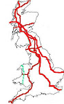
Blue = bike; red = foot
Being new to the cycling malarkey, and still getting to grips with what I find to be acceptably cyclable, I didn't know how far two wheels would take me on this one, but I guessed it would be far enough to justify the faff of getting the bike out.
Pedalling progress was slow, but when I found the obvious place to leave the bike, I had made it to within 100 yards of the track upon which I was going to be finishing my circuit. I'd pedalled 3.25 miles with 300m of ascent - which doesn't sound impressive on paper, but as a non-cyclist, I was disproportionately pleased with myself.
On foot, progress also started slowly as within five minutes I found myself having a massive dither about which way to go. Up through the old felled forest, or much further to go around? Up was my final decision and it was a good one. The felling was so old that even though there's still plenty of evidence of tree detritus, the progress of rot combined with grass growing over, gave easy passage.
Soon through the forest, all I then had to do was to make my way up a hillside that didn't look so daunting once on it as it had from a distance. In fact, being nice and grassy/mossy, with no tussocks or heather, it was much easier going than anticipated.
By the process of putting one foot in front of the other until there was no more 'up', the summit was gained, from where I looked over to Beinn a'Chleibh and Ben Lui, over which we walked on our first TGO Challenge, in 2009.
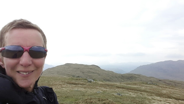
I couldn't help but also look carefully at the next lump on the ridge I was now on - the lump behind me in the snap above - which goes by the name of Meall nan Tighearn.
Whilst the map said otherwise, it looked higher from where I was standing and as, by this point, I'd decided not to do the third hill I had pencilled in for the day, I thought I may as well pop over to visit it. It looked higher when I was standing on it too, and having looked it up I see that: a) it's a Graham Top (yay! Bonus tick!); and b) current information has it as just 1m lower than Meall nan Gabhar.
My descent route would have been awful at most times of year, I imagine, as I made my way across a bowl/plateau that bore great evidence of its usual state of wetness. Today it crunched under my feet as I took a reasonably direct line to drop down to an old forest track which led me up to a new track which helped significantly in getting me to Beinn Bhalgrairean.
Out the top of the forest again, there was just a bit of rougher stuff before I was back on easy grass, which continued all the way to the top:
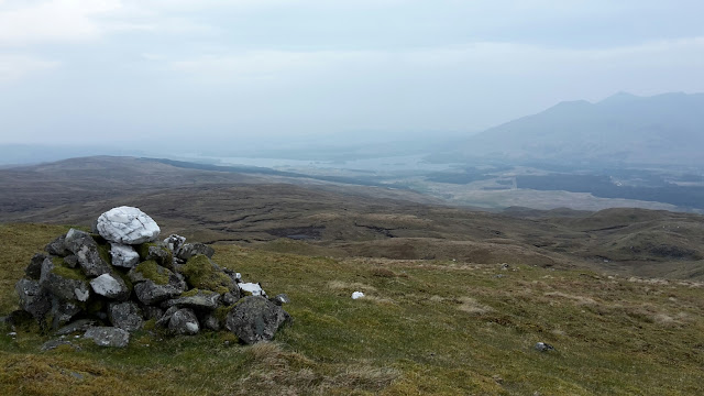
On top, looking towards Loch Awe - a bit hazy today
Retracing steps back down to the new track, it was then quick work to loop back around to my bike.
It had been a fine walk (far more enjoyable than I'd anticipated, based on the map and an inaccurate imagination), even if it did involve eight deer fence crossings (two via the same gate, six involving clambering. Fortunately the fences are new, taught and sturdy, so none involved swearing).
All that was left for me to do was to make my very timid descent, convinced that my bike was going to skitter on the loose surface on the track at any moment. Still, it was faster and less effort than walking.
(6.5 miles biked, 6.4 miles walked. Ascent as yet uncalculated.)
Today was the first day of the TGO Challenge, so I'm now solo as I make my way to the west coast (via a few hills), whilst Mick walks. After waving him off at the Youth Hostel (the sign-out point for Oban), off I went to:
Meall nan Gabhar (NN235242; 743m) and Beinn Bhalgrairean (NN203241; 636m) plus Meall nan Tighearn
Blue = bike; red = foot
Being new to the cycling malarkey, and still getting to grips with what I find to be acceptably cyclable, I didn't know how far two wheels would take me on this one, but I guessed it would be far enough to justify the faff of getting the bike out.
Pedalling progress was slow, but when I found the obvious place to leave the bike, I had made it to within 100 yards of the track upon which I was going to be finishing my circuit. I'd pedalled 3.25 miles with 300m of ascent - which doesn't sound impressive on paper, but as a non-cyclist, I was disproportionately pleased with myself.
On foot, progress also started slowly as within five minutes I found myself having a massive dither about which way to go. Up through the old felled forest, or much further to go around? Up was my final decision and it was a good one. The felling was so old that even though there's still plenty of evidence of tree detritus, the progress of rot combined with grass growing over, gave easy passage.
Soon through the forest, all I then had to do was to make my way up a hillside that didn't look so daunting once on it as it had from a distance. In fact, being nice and grassy/mossy, with no tussocks or heather, it was much easier going than anticipated.
By the process of putting one foot in front of the other until there was no more 'up', the summit was gained, from where I looked over to Beinn a'Chleibh and Ben Lui, over which we walked on our first TGO Challenge, in 2009.
I couldn't help but also look carefully at the next lump on the ridge I was now on - the lump behind me in the snap above - which goes by the name of Meall nan Tighearn.
Whilst the map said otherwise, it looked higher from where I was standing and as, by this point, I'd decided not to do the third hill I had pencilled in for the day, I thought I may as well pop over to visit it. It looked higher when I was standing on it too, and having looked it up I see that: a) it's a Graham Top (yay! Bonus tick!); and b) current information has it as just 1m lower than Meall nan Gabhar.
My descent route would have been awful at most times of year, I imagine, as I made my way across a bowl/plateau that bore great evidence of its usual state of wetness. Today it crunched under my feet as I took a reasonably direct line to drop down to an old forest track which led me up to a new track which helped significantly in getting me to Beinn Bhalgrairean.
Out the top of the forest again, there was just a bit of rougher stuff before I was back on easy grass, which continued all the way to the top:
On top, looking towards Loch Awe - a bit hazy today
Retracing steps back down to the new track, it was then quick work to loop back around to my bike.
It had been a fine walk (far more enjoyable than I'd anticipated, based on the map and an inaccurate imagination), even if it did involve eight deer fence crossings (two via the same gate, six involving clambering. Fortunately the fences are new, taught and sturdy, so none involved swearing).
All that was left for me to do was to make my very timid descent, convinced that my bike was going to skitter on the loose surface on the track at any moment. Still, it was faster and less effort than walking.
(6.5 miles biked, 6.4 miles walked. Ascent as yet uncalculated.)

No comments:
Post a Comment