After Wesnesday's exertions on the Romsdalseggen ridge, we found on Thursday, after we had relocated ourselves up to the Tollstigen Pass, that our weary legs weren't feeling like the length of walk I'd originally intended. Instead we opted for just a short circuit up to a nearby lake. The outward leg was just 1km but the 300m of ascent included in that distance took it out of the 'just a stroll in the park' category.
What a surprise we got when the lake came into sight - it was largely still frozen over:
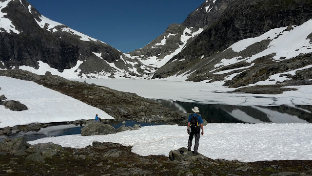
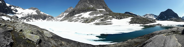
What a shame I hadn't packed a picnic!
The rest of the circuit gave us a gentler descent route and we returned to Bertie happy that our laziness had netted us the experience of such a spectacular location.
Back at Bertie we checked the weather forecast and, seeing that it was staying fine for Friday, we opted to stay put on the pass overnight so as to do Thursday's originally intended walk a day late.
Setting off before most tourists were up and about yesterday, the first part of the walk was gently up a broad u-shaped valley. Whilst in a lovely area, we must be getting picky as we both found the route itself relatively uninteresting. Knowing that the only option for our destination was an out-and-back, it started to feel like we had been sold a dud.
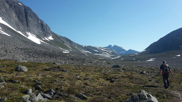
Believe it or not, a relatively uninteresting walk at this point
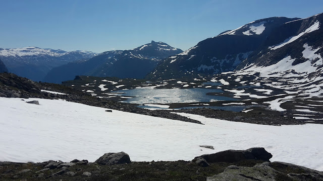
Then we got up to the highest lake on the route and everything changed.
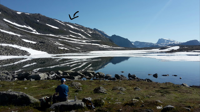
Elevenses at the lake. The arrow points to the distinctive rock on the ridge 'Mannen' that was our objective.
Snow patches and boulder fields had already been crossed to get to the lake, but beyond there they formed the entirety of the ascent up to the ridge. The snow was a good texture (although getting a bit soft at the end of the return leg) and I do like a good boulder field, even if they do demand undivided attention (I got distracted on one on the way down, losing first my rhythm then my nerve; they're a lot less fun when you're not able to stride across them).
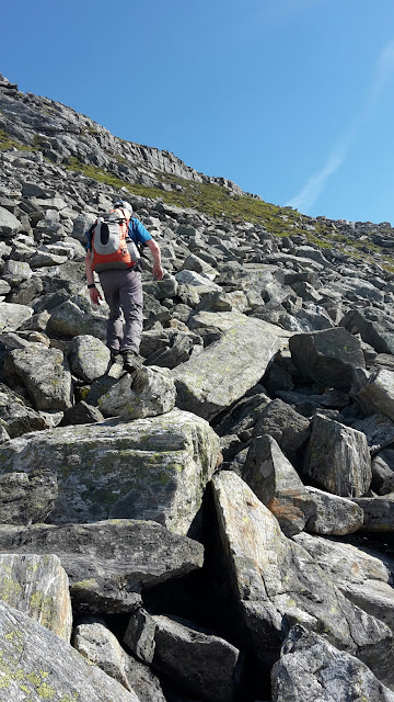
Boulder fields...
...and lots of snow...
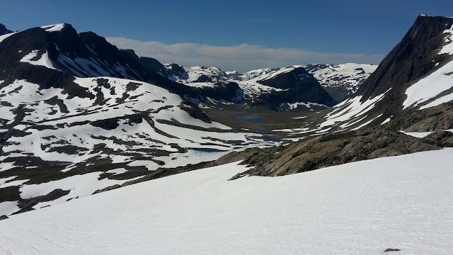
...and views down to more lakes...
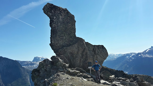
There are two things of note on top of this ridge, one is 'The Man':
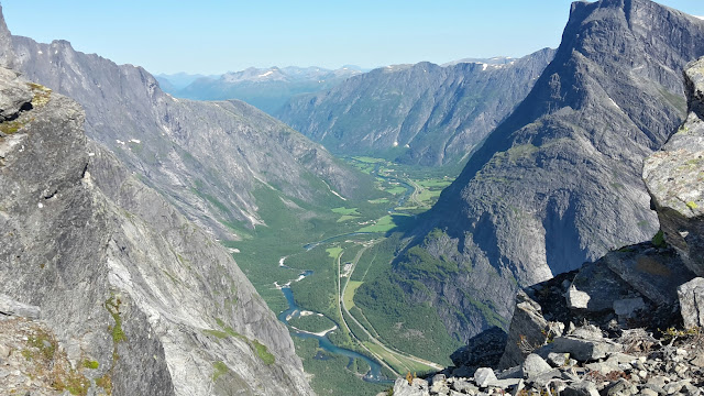
The other is a monitoring station, comprising a couple of buildings, helipad (under snow at the moment), a big water tank (we had followed the hose up from the lake below) and lots of CCTV cameras. As a result of the monitoring, it had been predicted that a huge chunk of this hill was going to fracture and fall at some point in 2014. It didn't happen and the hill has now stabilised. It was still a bit nerve wracking to be there amongst the monitoring equipment, and even more nerve wracking to stand on the edge and look down the almost sheer drop to the valley below:
We didn't start meeting people coming the other way until we were back past the highest lake, and we were a good way back before we paused for lunch. With this being a 14.6km outing with 600m ascent, I had expected to be back by lunchtime. However, I had also believed that this was a 'blue' (medium) grade of walk. It turned out when I looked again later that the blue walk stopped lower down the valley and the final section was of red (difficult) grade. What I expected to take 3.5 to 4 hours thus actually took 5 (although I suppose that did include elevenses and lunch breaks), but I have no complaints - contrary to first impressions during the first half an hour, it was a thoroughly enjoyable outing.
What a surprise we got when the lake came into sight - it was largely still frozen over:
What a shame I hadn't packed a picnic!
The rest of the circuit gave us a gentler descent route and we returned to Bertie happy that our laziness had netted us the experience of such a spectacular location.
Back at Bertie we checked the weather forecast and, seeing that it was staying fine for Friday, we opted to stay put on the pass overnight so as to do Thursday's originally intended walk a day late.
Setting off before most tourists were up and about yesterday, the first part of the walk was gently up a broad u-shaped valley. Whilst in a lovely area, we must be getting picky as we both found the route itself relatively uninteresting. Knowing that the only option for our destination was an out-and-back, it started to feel like we had been sold a dud.
Believe it or not, a relatively uninteresting walk at this point
Then we got up to the highest lake on the route and everything changed.
Elevenses at the lake. The arrow points to the distinctive rock on the ridge 'Mannen' that was our objective.
Snow patches and boulder fields had already been crossed to get to the lake, but beyond there they formed the entirety of the ascent up to the ridge. The snow was a good texture (although getting a bit soft at the end of the return leg) and I do like a good boulder field, even if they do demand undivided attention (I got distracted on one on the way down, losing first my rhythm then my nerve; they're a lot less fun when you're not able to stride across them).
Boulder fields...
...and lots of snow...
...and views down to more lakes...
There are two things of note on top of this ridge, one is 'The Man':
The other is a monitoring station, comprising a couple of buildings, helipad (under snow at the moment), a big water tank (we had followed the hose up from the lake below) and lots of CCTV cameras. As a result of the monitoring, it had been predicted that a huge chunk of this hill was going to fracture and fall at some point in 2014. It didn't happen and the hill has now stabilised. It was still a bit nerve wracking to be there amongst the monitoring equipment, and even more nerve wracking to stand on the edge and look down the almost sheer drop to the valley below:
We didn't start meeting people coming the other way until we were back past the highest lake, and we were a good way back before we paused for lunch. With this being a 14.6km outing with 600m ascent, I had expected to be back by lunchtime. However, I had also believed that this was a 'blue' (medium) grade of walk. It turned out when I looked again later that the blue walk stopped lower down the valley and the final section was of red (difficult) grade. What I expected to take 3.5 to 4 hours thus actually took 5 (although I suppose that did include elevenses and lunch breaks), but I have no complaints - contrary to first impressions during the first half an hour, it was a thoroughly enjoyable outing.

No comments:
Post a Comment